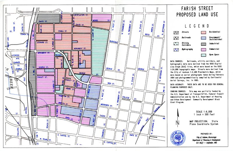
Farish Street Existing Land Use Map
- Title
- Farish Street Existing Land Use Map
- Date
- 1992-09
- Creator
- City of Jackson, Mississippi Department of Planning & Development GIS Staff
- Description
- A map of the Farish Street Historic District with markers for different land uses: streets, railroads, utility corridors, hydrography, residential, government/institutional, industrial, commercial, and open space.
- Primary Subject
- 1900-1999 | Urban Life | Business
- Additional Subject
- Architecture
- Location
- Farish Street Historic District | Jackson | Mississippi
- Type
- Map
- Medium
- Paper
- Measurements
- 17 in x 11 in
- Format
- JPEG
- HBCU Identifier
- mwchcac.oh.2022.fsp.photo3
- HCAC Identifier
- HCAC.JSU.0015
- Rights
- All rights held by the Margaret Walker Center. For permission to publish, distribute, or use this image for any other purpose, please contact Margaret Walker Center, Jackson State University, 601-979-3935 Attn: Center Director
- Contributing Institution
- Jackson State University
- Source
- Supplementary photograph collection with The Farish Street Project Oral History Collection
- Collection
- The Farish Street Project Oral History Collection
A photo of a map of the Farish Street Historic District produced by the City of Jackson, Mississippi, Department of Planning & Development: GIS Staff in September of 1992.
The map includes markers for different land uses: streets, railroads, utility corridors, hydrography, residential, government/institutional, industrial, commercial, and open space.
From the end of Reconstruction until the mid-1960s, Farish Street in Jackson was a center of business, social, and cultural activities for Black Jacksonians and Mississippians. By the 1980s, much of Farish Street had fallen into disrepair due to neglect and flight from the neighborhood.
Several prominent businesses still remain in the district and many efforts have been made over the years to redevelop the area around those businesses, but lack of city interest, systemic racism from state government agencies, and difficulty in finding developers willing to take on the larger projects associated with redeveloping a historical neighborhood have all contributed to the neighborhood remaining in the state it is in now: far from its former glory but still made up of residents and businesses proud of their place in the city.
This map would have been used for the planning of some of the earlier attempts at redevelopment in the Farish Street District.